"I'm a surveyor because engineers need heroes too"
At Dudos
Engineering, we offer precise and comprehensive topographical and
detailed survey services that form the backbone of successful
construction, infrastructure, and land development projects. Our ground team
comprises of trained and experienced surveyors with precise equipments for high
precision survey and location based data collection.
Surveys
are typically a first step in any construction or development project, it is
necessary to perform a survey to identify various details like area of land,
existing structure details, dimensions, contour & elevations with
remarkably accurate results. Having a detailed and accurate picture of your
land can reduce the risk of costly downstream mistakes caused by unforeseen
issues.
What is a Topographical Survey?
A
topographical survey involves mapping the natural and man-made features of a
land area. This includes the measurement of land elevations, contours, and
terrain details, as well as capturing features such as buildings, roads, trees,
and utilities. These surveys are essential for creating accurate site plans,
civil engineering designs, and ensuring that projects are built in harmony with
the land’s characteristics.
Detailed Survey for Precision Planning
Our detailed
surveys go beyond basic land measurements to include precise data on
property boundaries, infrastructure, utilities, and underground structures.
This type of survey is critical for projects that require exact specifications,
such as road designs, drainage systems, forest diversion and
large-scale urban planning.
Why Choose Dudos Engineering for Your Topographical & Detailed Surveys?
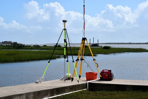
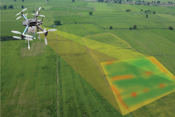
1. Advanced
Surveying Equipment: We
utilize the latest in Total Stations, DGPS, Drone, GPS, Auto level and
LiDAR technology to provide accurate, reliable data. These tools allow
us to perform high-resolution surveys over large and complex areas.
2. Expert
Team: Our
team of experienced land surveyors and engineers have extensive knowledge of
both urban and rural landscapes. We deliver tailored solutions to meet the
specific needs of each project, ensuring that every detail is captured with
precision.
3. Comprehensive
Survey Solutions: From boundary
demarcation to 3D terrain modelling, we provide a
wide range of topographical and detailed survey services that address the
unique requirements of each client.
4. Accurate
Data for Better Decision-Making: With
our surveys, you receive detailed reports and maps that give you a complete
understanding of the site's conditions. This enables informed planning,
accurate budgeting, and a smoother construction process.
Our Topographical & Detailed Survey Services Include :
1. TBM/
GTS marking: A
temporary benchmark (TBM) is a fixed point with a known elevation that is
used as a reference point to control levels during construction and surveys.
2. Contour
Mapping: Providing
a detailed representation of the land’s elevation and slopes.
3. Boundary
Surveys: Accurate
identification and mapping of property lines to avoid disputes and legal
issues.
4. Site
Plans: Creation
of detailed plans for construction, development, or infrastructure projects.
5. 3D
Terrain Models: Advanced
3D modelling for more complex visual representation of the land, useful for
architects and planners.
6. As-Built
Surveys: Verifying
that the construction of buildings or infrastructure is in accordance with
approved plans.
7. Utility
Mapping: Detailed
mapping of underground utilities like pipelines, electrical cables, and sewer
systems to prevent project delays or hazards.
8. Bathymetric
survey: A
bathymetric survey is a method for mapping the underwater features and
measuring the depth of a body of water. Bathymetric surveys are a type of
hydrographical survey and are used for a variety of construction purposes
including dam, bridges, Intake well, Reservoir etc.
Industries We Serve
1. Construction
and Real Estate: Providing
accurate site data for building layout, foundation planning, and development
strategies.
2. Transportation
& Infrastructure: Assisting
in the planning and design of roads, highways, railways, and bridges,
ensuring alignment with existing landscapes.
3. Environmental
Projects: Supporting
sustainable land development by accurately mapping topography for environmental
impact assessments.
4. Utilities
& Energy: Surveying
for the installation of pipelines, powerlines, and renewable energy
projects such as wind farms and solar plants.
5. Urban
Planning & Development: Helping
cities and municipalities with land surveys for zoning, road networks, and
public infrastructure planning.
The Dudos Engineering Difference
At Dudos
Engineering, we pride ourselves on providing accurate, efficient, and
professional surveying services. Our focus on precision, attention to detail,
and cutting-edge technology makes us a trusted partner for developers,
engineers, and contractors. From small residential projects to large-scale
industrial developments, we ensure that every project has a strong foundation
of reliable survey data.
Contact
Dudos Engineering today
to learn more about how our topographical and detailed survey services can
help streamline your project and provide the insights you need to succeed.